

New Hampshire's White Mountains provide more than breathtaking scenery and popular tourist destinations. They rank among the most popular hiking and climbing locations in the country. The Appalachian Trail traverses the state on its route from Maine to Georgia via the Presidential and Franconia ranges' ridgelines, across Mount Washington's summit, and through a sizable wilderness area.
The Appalachian Mountain Club (AMC) runs huts along the trail that are spaced a day's journey apart where hikers can stay and eat with other mountain lovers. Get the most recent AMC White Mountains Guide, make sure you have plenty of water and warm gear in your pack, and check the weather forecast before beginning any of these mountain hikes. Above the tree line, sudden and abrupt weather changes are frequent, and snow has fallen here during the whole year.
The AMC Highland Center is a suitable starting point for hikers in the White Mountains, offering a hostel, gear rentals, up-to-date trail information, and led walks for both beginners and experienced hikers. Longer trails can be taken without having to circle back to the same trailhead thanks to a hiker shuttle.
There are treks and climbs in New Hampshire's southern region as well; not all of the state's mountains are located in this northern range. This list contains challenging paths as well as shorter climbs to waterfalls and even mountaintops that are appropriate for children and hikers who are not interested in challenging multi-day hikes.
With this selection of the best hiking trails in New Hampshire, you may explore the breathtaking scenery of the region.
Mountain Monadnock
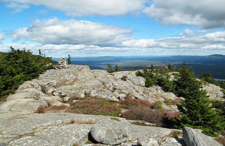
Monadnock, rumored to be the world's most popular mountain to climb, rises alone in southwestern New Hampshire, where its rocky top affords 360-degree vistas that, on a clear day, extend as far as Boston.
There are several different hiking trails available. The White Cross Trail, which covers moderate terrain and takes four hours roundtrip, is the most well-liked. It starts at the Monadnock State Park entrance along US 101 in Jaffrey. From Dublin Lake's shores, which are also along US 101, the lengthier Pumpelly Trail ascends the opposite side of the mountain. It is more challenging but offers more variety. The Pumpelly Trail is a six to seven-hour round-trip hike that starts with a foray into the woods and ends with a scramble over rocks and stones as it climbs and descends over a rocky ridge above the tree line.
Even on a hot day, the mountain can be windy because it is isolated and 1,000 feet taller than any other peak within 30 miles or so. The weather can also change suddenly. Whichever of the trail you choose, the rocky summit can be dangerous when wet, and fog can quickly descend and make it difficult to see the trail. Note that it is simple to get to the peak from Boston and that this is a fairly popular climb, so don't anticipate being by yourself on a lovely day. The Monadnock Inn, a sizable B&B-style inn with antique decor and modern services, is a handy spot to stay close to Mt. Monadnock. Try the Benjamin Prescott Inn, a traditional New England inn, for more opulent accomodation.
2. Ammonoosuc Ravine Trail on Mount Washington
The ascent of the Northeast's highest peak following the Ammonoosuc River, one of the Presidential Range's most rewarding hikes, presents a sequence of waterfalls, cascades, and views that rival those of any other route up the mountain.
At the trailhead, which is close to the Base Station of the Mt. Washington Cog Railway, it takes a full day to trek the nine miles roundtrip to the summit. You'll pass Lakes of the Clouds and the AMC chalet below the peak. By using the Jewell Trail, which has a much easier descent and its own lovely landscape, you can get back to the trailhead.
Remember that no matter how warm it is at the base, it is always cold at the summit of Mount Washington, where Arctic equipment is tested and the highest land wind velocity ever measured. Weather is unpredictable, and visibility is reduced to nothing when clouds gather over the peak.
Three. Champney Falls Trail on Mount Chocorua
The image of the most photographed mountain in New England, standing virtually by itself with its recognizable peak reflected in Chocorua Lake, is well-known. The Piper Trail, the most popular trail, departs from Road 16 not far from the lake and the well-known scenery.
11 Top-Rated Hiking Trails in New Hampshire #NationalTakeAHikeDay
— The Residences at Manchester Place (@Manch_Place) November 17, 2022
https://t.co/oGuqSkyJrX pic.twitter.com/ol9fvtWCmT
However, you can climb using the Champney Falls Trail, a longer but more interesting and varied path, from the Kancamagus Highway (Route 112). Also, it offers you the chance to do a loop that brings you back to the original trailhead within 100 yards by using a different trail. A side trail leading to Champney Falls and nearby Pitcher Falls can be found a little more than a mile into the ascent. If you're not ready for the round-trip climb to the summit and back, this makes a good shorter hike, but the falls might not be spectacular if the weather has been dry.
A rocky ledge forms the summit of Mount Chocorua, and this trail connects to the Piper Trail to go there. Use the Bee Line and Bolles trails if you want to take a longer way back, but be warned that it will take over 10 miles total and need another climb via a pass that not many people are even aware of.
Before tackling this route, make sure you have a trail map and the most recent AMC White Mountains Guide. Keep an eye on the weather because Chocorua's rocky peak might be dangerous if it's raining, icy, or covered in clouds.
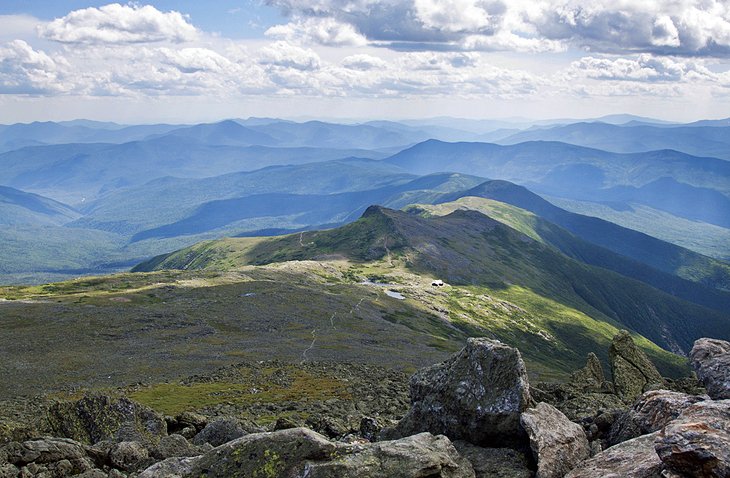
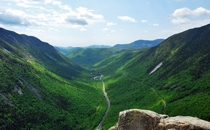
4. Crossing the Presidential Range on the Appalachian Trail
Crossing the Presidential Range and passing over Mount Washington's top, the tallest mountain in the northeast, is one of the most picturesque parts of the entire Appalachian Trail. AMC huts that offer bunks and food are scattered along the route, and a hiker shuttle allows hikers to travel from hut to hut without having to go back.
Depending on how many side trails you choose to take, a multi-day trip from US 2 in Randolph to US 302 in Crawford Notch will cover 13.5 to 18 miles and require moderate to strenuous hiking. Since it is mostly above timberline, weather is a crucial factor. If you aren't in good shape, have everything you need, and are carrying the most recent AMC White Mountains Guide, don't even consider trying it.
The Appalachian Trail is joined at Madison Springs Hut, which is reached by ascending from Randolph (the Valley Way Trail is the quickest and safest approach). One of the nicest views in the White Mountains may be found from this location. With side routes leading to the peaks of Adams, Jefferson, Clay, and Mount Washington itself, the Appalachian Trail traverses the ridgeline. The sections between Madison Springs and Lakes of the Clouds Hut are the highlights of this airline route.
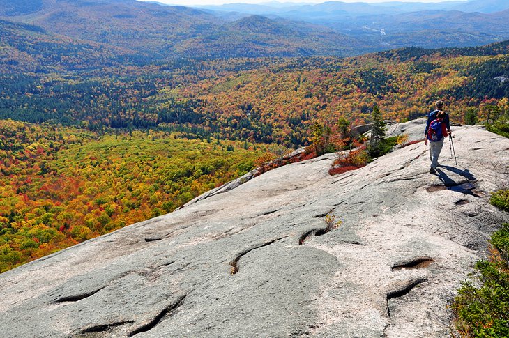
(5) Mount Willard
Climbers are rewarded with one of the best vistas of the White Mountains below timberline on this diminutive summit that stands in the way of Crawford Notch. The track ascends through chilly woodlands for just over three miles roundtrip before emerging onto the cliffs.
You will like this panorama of Crawford Notch as it spreads out below you (and to wild blueberries in mid-summer). There is no better location to understand how the glaciers cut and smoothed out the notch in New Hampshire as they retreated.
It's an excellent family hike, but if you're hiking with kids, be careful that the plunge is steep and sudden. There are two more shorter hikes: one around the lake and up to the Elephant Head rock formation, and the other to Beecher Falls, both of which can be started from the parking lot next to small Saco Lake.
The Notchland Inn, located at Crawford Notch's base and close to Mount Willard, offers opulent accommodations, cottages, and a top-notch dining area. Pets are welcome at the inn, which also has a game area, gift store, and free breakfast. The majority of the guest rooms have fireplaces.
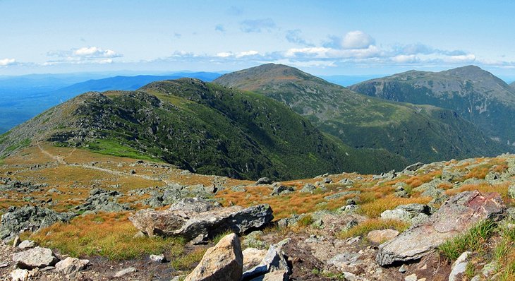
6. Trail around Franconia Notch Ridge
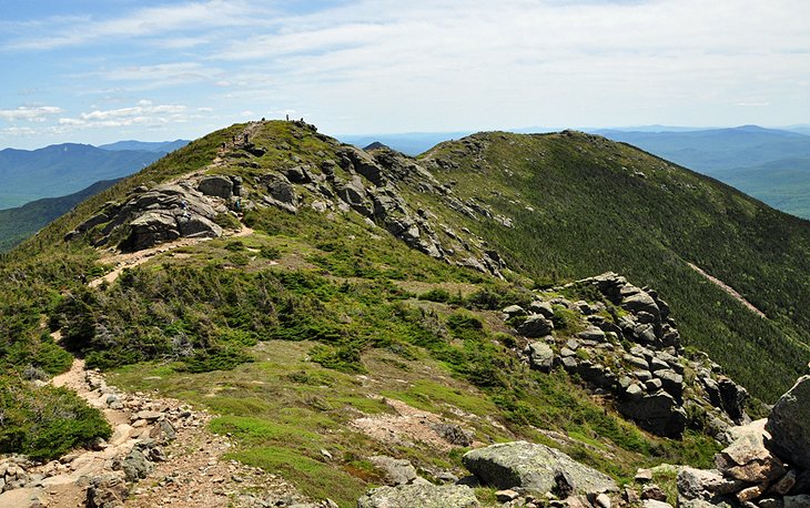
The eight-mile journey along the crest of the Franconia Ridge delivers a similar multi-peak experience, albeit it is a little shorter than the hike over the Presidential Range and this time adds the excitement of a knife-edge trail with mountainsides rapidly dropping down on either side.
This round trek takes about eight hours to complete, but you may break it up by spending the night at the Greenleaf Hut. Throughout the descent down Falling Waters Trail, three mountain summits and a string of waterfalls are added bonuses in addition to the stunning vistas down into Franconia Notch.
It's a good shorter climb for families to complete the entire loop from Cloudland Falls to Lafayette Campground, which is where it starts and ends. Bring your bathing suits on a hot day so you can cool off in one of the pools.
Basin-Cascades Trail 7.
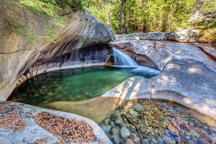
Rarely does a hiking trail start off with two fantastic kid-friendly stops before you even start the ascent. A glacial stream formed and blasted the enormous pothole known as The Basin. Even if you don't hike the trail that starts here, the signage next to it recounts how the route was formed, so it's worth a stop.
A short distance away lies one of the state's most alluring and accessible waterfalls, a long, leisurely cascade over a number of ledges that urge climbing or sitting to take in the scene. The trail next to the falls leads to a large collection of picnic-friendly falls and cascades over level ledges.
Kinsman Falls is located a half-mile above the initial cascades, and from there, the trail ascends tougher terrain to Rocky Glen Falls. Over this, you can continue, climbing to Lonesome Lake while crossing a wooden bridge, but the terrain gets too difficult for small legs.
Park at the The Basin exit and walk through the tunnel under the highway to reach the trailhead. The family-friendly Indian Head Resort, which has a swimming pool that will be appreciated after the climb, is only a few miles south of The Basin.
8. Zealand Falls and Thoreau Falls
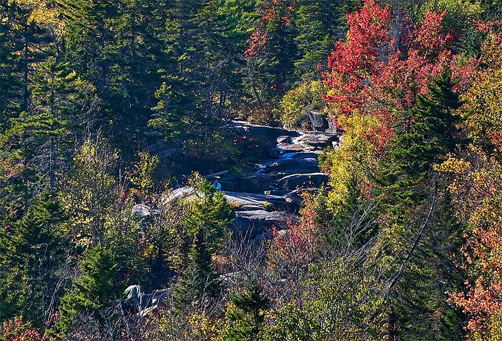
The 4.8-mile journey to Thoreau Falls, one of New Hampshire's lesser-known waterfalls, can be cut short by stopping at the 2.7-mile Zealand Falls. In either case, stop at the AMC Zealand Falls Hut for a refreshing beverage and the porch's view of Zealand Notch. Since there are no roads leading to this little-known notch, only hikers can see it.
Start your journey at Zealand Road's terminus, which is where it splits off from Route 302 at the Zealand campground between Twin Mountain and Bretton Woods. The trail's first two miles are spent in coniferous trees and along the former logging train bed before it skirts a pond. The Ethan Pond and Twinway trails meet near the Zealand Trail's terminus. On the right, Twinway climbs up next to Zealand Falls and provides views of the deep, U-shaped Zealand Notch as well as access to the AMC cabin.
Take the woodland Ethan Pond Trail on the left after Zealand Falls to reach Thoreau Falls. The Thoreau Falls Trail is identified by a sign, and soon you'll emerge onto the ledges at the head of the falls. They lead to a 20-foot straight drop after a sequence of cascades, pools, and channels. The foot of the falls is accessible by a trail for a fresh set of views.
9. Path of Pawtuckaway Boulders
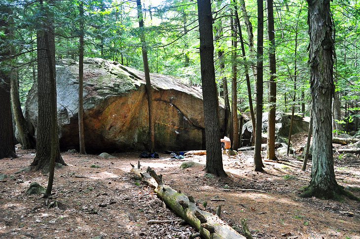
As the glaciers were active throughout the previous Ice Age, New Hampshire has a wealth of natural attractions. Massive boulders known as "glacial erratics" can be found all across New Hampshire, although the majority of them are in the state's northern region.
Yet few sites have such a magnificent collection of these as Pawtuckaway State Park, which is located between Concord and Portsmouth not far from the Massachusetts border. Granite boulders the size of small houses that appear to have been thrown here by a giant hand while really having been scraped off of mountaintops and cliffs exposed by the melting glaciers can be found deep in the forest.
If you take the side trail to the Devils Den, a pair of caverns at the foot of a tall stone outcrop, Boulder Trail becomes a two-mile loop. There are also two small mountains in the park that you can climb, a lake, and a campground. You can find park maps online or in the actual park.
10. Waterville Valley's Welch-Dickey Trail
The ski and summer resort with the same name is the most well-known feature of Waterville Valley, which sits on the southern edge of the White Mountains. But, there is more to this Mad River valley than meets the eye. It extends deep into a large wilderness region that makes up the southern portion of the White Mountain National Forest.
The Welch and Dickey mountains are connected by an about 4.5-mile trail that ascends to a series of level and gradually sloping ledges. There is no need to go backwards because the trail makes a loop. The mountains are not extremely tall in comparison to the mountains further north, but they are distinct and their tops offer views that extend unexpectedly far.
This is a great trail for kids, but you shouldn't trek it shortly after it has rained because the smooth granite ledges can become very slick. For this and several other excellent short hikes in the valley, pick up a copy of Walking Trails of Waterville Valley at the resort's Jugtown Shop. From Route 49, take Upper Mad River Road to Orris Road to get to the trailhead.
The self-contained resort community of Waterville Valley offers a variety of housing options, including the Snowy Owl Inn, which is particularly popular with families due to its sizable indoor pool.
11. The Mt. Rollins Trail
Mt. Kearsarge, which rises 2,937 feet, can be climbed from either of two state parks. It's a moderately difficult mile-plus hike from the Winslow State Park side. By taking the Barlow Trail from just below the summit and completing a loop back to the parking lot, you can change up the route you take back. There are ledges and other vistas throughout the 1.7-mile Barlow Trail.
The distance to the fire tower at the summit from the road's end in Rollins State Park is about a mile. From the same parking space, you can take the Lincoln Trail for a longer but still manageable ascent to the summit.
Visitors are typically welcomed by the rangers when the tower is staffed in the summer and fall. Although though Mt. Kearsarge is only 3,000 feet tall, it is the only mountain in the area, giving visitors a 360-degree vista that includes multiple lakes, the White Mountains, and Vermont. From the same parking space, you can take the Lincoln Trail for a longer but still manageable ascent to the summit. Not to be confused with the other Mt. Kearsarge in the North Conway area.